09 July 2026
Coastal erosion monitoring a snap with new station
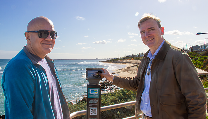
Residents and visitors can play an active role in protecting our coastline from erosion with the installation of a CoastSnap station at Mettams Pool.
Last update date: 14 July 2026
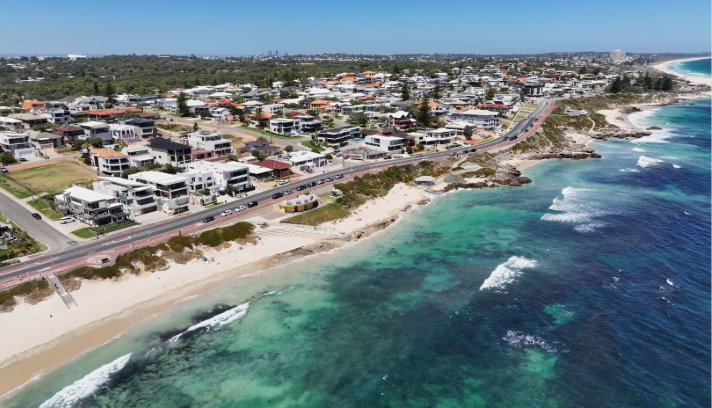
The City, with its 7km coastline, faces coastal hazards like erosion and inundation. It developed the CHRMAP to mitigate these risks.
The City has approximately 7km of coastline, including iconic beaches.
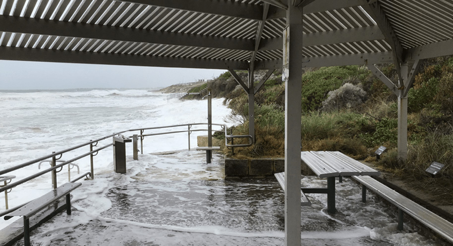
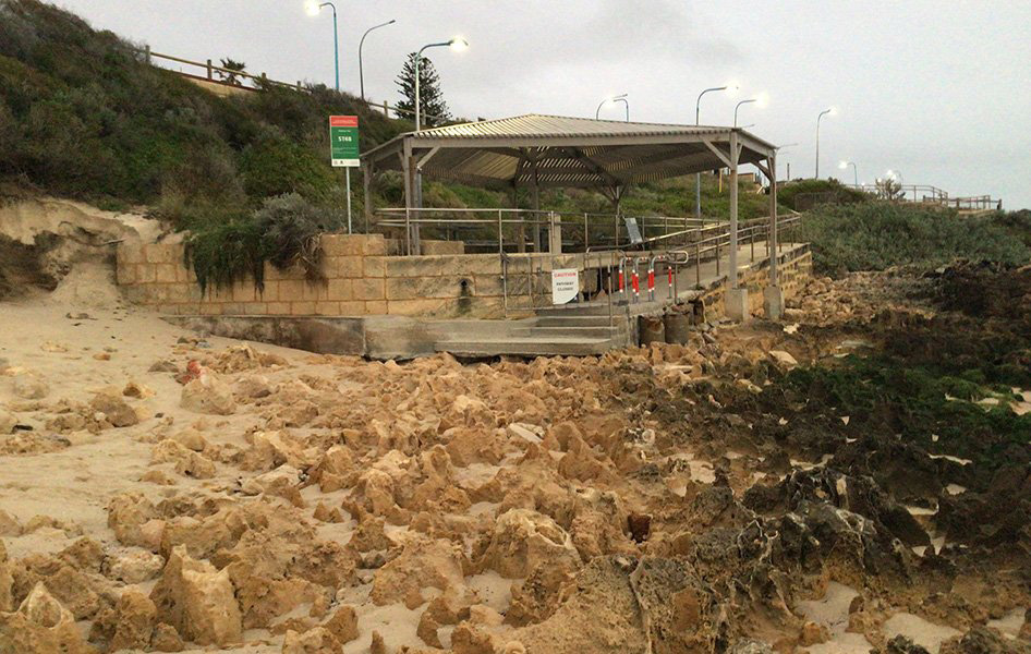
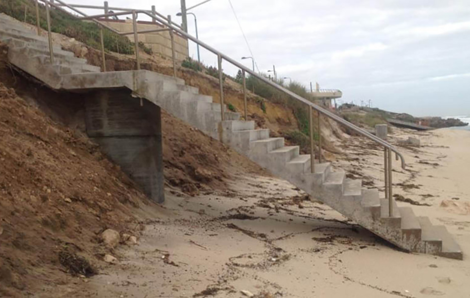
Erosion is the main coastal hazard impacting the City of Stirling coastline. Erosion can occur in a short time period - for example, a storm event - or over a longer period of time, as the shoreline gradually retreats due to rising mean sea level or changes in local coastal process.
If erosion occurs where assets exist, the damage is generally permanent. Erosion, however, is not necessarily permanent, with sandy beaches often eroding and recovering seasonally. Both erosion and inundation hazard extents will be mapped for the CHRMAP, at various timeframes from present day to 2120.
In preparation for the CHRMAP, the City consulted extensively with the community and stakeholders to identify high-priority assets and considerations for our precious coastline. The CHRMAP provides strategic guidance for coordinated, integrated and sustainable land use planning and management and is a long-term plan that informs the City’s future decision.
The City engaged a range of specialist advisory services to complete a Coastal Hazard Risk Management and Adaptation Planning (CHRMAP) process.
In 2019, an Assessment of Coastal Erosion hotspots in Western Australia (prepared by the Department of Planning, Lands and Heritage and the Department of Transport), identified Mettams Pool and Watermans Bay as two of 55 coastal erosion hotspots along the West Australian coast.
The CHRMAP classified Mettams Pool and Watermans Bay as high risk of being impacted by coastal erosion and recommended further investigation in the immediate term and, depending on the outcomes, active management in the short term.
The recommendation (CHRMAP Chapter 5 R13) is to “Undertake a detailed options assessment to determine the optimal coastal protection technique(s) at Watermans Bay Beach and Mettams Pool Beach” through a working group which incorporates a community/stakeholder feedback mechanism.
The options assessment process was undertaken by a project working team comprising Elected Members, City and State Government representatives, led by specialist coastal engineers.
Four primary options were investigated using a Multi-Criteria Assessment that reviewed the technical, social, environmental and economic aspects each option: beach nourishment, groyne/headlands enhancements, nearshore reefs/breakwaters and seawalls.
Sand nourishment was identified as the preferred short-to-medium-term option to maintain beach amenity and protect against erosion at Mettams Pool and Watermans Bay.For further information, you can view the Minutes of the Ordinary Council Meetings held on 27 May 2025 and 31 March 2026.
In March 2026, the City formed a Coastal Protection Working Group with members of the community with a special interest in coastal protection through an Expressions of Interest process. The aim of the newly formed group is to share knowledge about coastal issues and provide a community perspective on coastal protection works.
A CHRMAP is a strategic planning document that outlines management and adaptation pathways for areas and assets at risk of coastal hazards, such as erosion and inundation (flooding). Assets include both built and natural assets, which provide a range of values to the community, including social, environmental, economic and heritage values.
CHRMAPs provide the basis for planning instruments such as Local Planning Schemes, Local Structure Plans and Foreshore Management Plans, by presenting the context around existing and future coastal vulnerability and the framework for managing associated risk.
The CHRMAP is required under the State’s Coastal Planning Policy (SPP2.6), under the Planning and Development Act 2005. The CHRMAP provides long term strategic direction, while identifying risk and required decision making in the shorter term.
Coastal vulnerability is a result of a number of factors including:
Due to a combination of these, the coastal vulnerability is expected to increase significantly in the future. These factors are already putting coastal assets at greater risk and requiring a more strategic approach to Coastal Hazard Risk Management and Adaptation Planning.
The CHRMAP eliminated several options and identified the following options that are deemed appropriate:
Detailed design of preferred option: The City plans to commission a consultant to undertake the detailed design for the preferred option at Mettams Pool.
Development of a Foreshore Management Plan: In accordance with Recommendation 16 of the CHRMAP, the City plans to commission a consultant to develop a Foreshore Management Plan for the preferred option at Mettams Pool.
Strategic partnership with other Local Governments: In accordance with Recommendation 3 of the CHRMAP, the City played a key role in establishing a strategic partnership with the City of Joondalup and the City of Wanneroo, forming the Northern Beaches Alliance (NBA). The group, also including the Town of Nedlands and the Town of Cambridge, is chaired by the City of Wanneroo. The NBA facilitates joint submissions under various state government agency programs to collectively advance coastal projects.
Investigation to identify suitable sediment sources: In accordance with Recommendation 15 of the CHRMAP, the City has been collaborating with the NBA to actively investigate potential sources of marine sediment for beach nourishment. Several potential sediment sources have been identified, and a consultant has been engaged to verify these sources.


For more information, or to receive this information in an alternate format, please contact the City on (08) 9205 8555 or visit www.stirling.wa.gov.au/enquiry.
City of Stirling kaadatj Nyoongar moort Nyoongar boodja-k Wadjak boodja-k. Ngalak kaadatj Nyoongar nedingar wer birdiya koora koora wer yeyi. Baalabang koondarm, malayin wer nakolak baalap yang ngalany-al. Ngalak dandjoo barn wer kaaratj bandang boodja-k.
The City of Stirling acknowledges the traditional custodians of this land, the Wadjak people of the Nyoongar Nation, and pays respect to the Elders both past and present for they hold the memories, the traditions, the culture and hopes of Aboriginal Australia.